 IMS-22, GIS overview map of potential rapidly moving landslide hazards in western Oregon, by R. Jon Hofmeister, Daniel J. Miller, Keith A. Mills, Jason C. Hinkle, and Ann E. Beier, 2002.
[Go back] | Publications Center | DOGAMI Home
IMS-22, GIS overview map of potential rapidly moving landslide hazards in western Oregon, by R. Jon Hofmeister, Daniel J. Miller, Keith A. Mills, Jason C. Hinkle, and Ann E. Beier, 2002.
Text report that accompanies IMS-22 publication
Full IMS-22 publication (311 MB .zip file)
Index map (PDF) for the 1:100,000 quadrangles shown below
1:100,000 quadrangle PDFs displaying GIS data from IMS-22:
Astoria
Bend
Canyonville
Coos Bay
Corvallis
Cottage Grove
Crater Lake
Crescent
Diamond Lake
Eugene
Gold Beach
Grants Pass
Hood River
La Pine
Madras
McKenzie River
Medford
Mount Hood
Mount Saint Helens
Nehalem River
Newport
North Santiam River
Oakridge
Oregon City
Port Orford
Reedsport
Roseburg
Vancouver
Waldport
Yamhill River
Introduction: The map PDFs linked from this page display potential rapidly moving landslide hazard zones contained within the GIS files of DOGAMI publication IMS-22 (2002). The potential rapidly moving landslide hazard zones shown apply specifically and only to debris flow hazards. Debris flows are mixtures of water, soil, rock, and/or debris that have become a slurry and commonly move rapidly downslope.
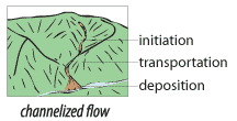
The work described by that publication used the best topographic data available at the time, the U.S. Geological Survey's 10-m digital elevation models (DEM). The topography is therefore similar to that depicted on USGS 1:24,000-scale topographic maps. These landslide hazard zones generally reflect areas on or at the bases of steep slopes, within stream channels, and at stream channel mouths, as depicted in Figure 23 on page 25 of IMS-22.
More Recent and More Accurate Lidar-Derived Topographic Data Impact: Although the text of IMS-22 predicted that these hazard zones should capture between 80% and 95% of landslide hazard deposition areas, more recent work by the Department using much higher resolution topographic data indicates that these IMS-22 maps not only show large areas of hazard zones where there may be none but also may fail to capture a majority of actual deposition zones at the mouths of stream channels. Therefore, although the descriptions of the hazard and methodology remain valid, the IMS-22 hazard zones are now considered to be an inaccurate depiction of this hazard. As a result, site-specific studies are always necessary to confirm or to refute the existence of a hazard.
Disclaimer: These illustrations and the GIS data behind them cannot serve as substitutes for site-specific investigations by qualified practitioners; site-specific reports could give results that differ from those shown here. No warranty, expressed or implied, is made regarding the accuracy or utility of the information described and/or contained herein, nor shall the act of distribution constitute any such warranty. This disclaimer applies both to individual use of the data and aggregate use with other data. The Oregon Department of Geology and Mineral Industries shall not be held liable for improper or incorrect use of this information.