 Open-File Report O-23-07, A GIS-Based Toolbox for Improved Efficiency and Precision of Landslide Inventory Mapping, by Jon J. Franczyk, William J. Burns, and Nancy C. Calhoun.
[Go back] | Publications Center | DOGAMI Home
Open-File Report O-23-07, A GIS-Based Toolbox for Improved Efficiency and Precision of Landslide Inventory Mapping, by Jon J. Franczyk, William J. Burns, and Nancy C. Calhoun.
Landslides are one of the most widespread and damaging natural hazards in Oregon. To reduce losses from landslides, areas of landslide hazard must first be identified. The inventory can be used to create susceptibility maps that display areas likely to have landslides in the future. After landslide hazards have been identified on inventory and susceptibility maps, the risk can be quantified, and mitigation projects can be prioritized and implemented.
In 2009, the Oregon Department of Geology and Mineral Industries (DOGAMI) published Special Paper 42 (SP-42), “Protocol for Inventory Mapping of Landslide Deposits from Light Detection and Ranging (Lidar) Imagery” (Burns and Madin, 2009), a roadmap developed to create and maintain a consistent landslide inventory for the state of Oregon. This publication and associated ESRI ArcToolbox, called the SP-42 Toolbox, are designed to assist landslide mapping following the SP-42 method by improving its efficiency and precision.
O-23-07 PUBLICATION CONTENTS
Report text only (23 p., 1.2 MB PDF)
Full GIS data bundle (41.3 MB .zip file): SP-42 Toolbox for ArcMAP, SP-42 Toolbox for ArcPRO, and metadata
SP-42 Toolbox for ArcMAP (20.1 MB .zip file)
SP-42 Toolbox for ArcPRO (20.0 MB .zip)
Full publication bundle (42.4 MB .zip file) - text report, SP-42 Toolbox for ArcMAP, SP-42 Toolbox for ArcPRO, and metadata
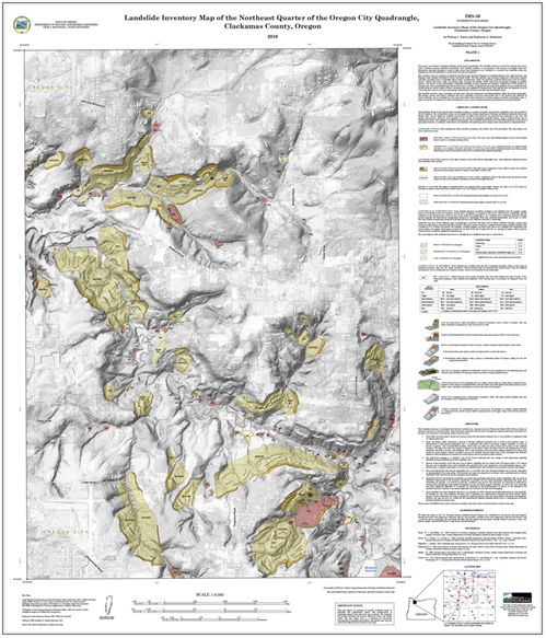
Example of a landslide inventory map based on SP-42 protocol (Plate 1 from Interpretive Map 30):