DOGAMI Geologic Map Series
[Go back] | Publications Center | DOGAMI Home
Publication Preview
 GMS-120, Geologic map of the Devine Ridge South 7.5' quadrangle, Harney County, Oregon, by Clark A. Niewendorp, Carlie J. M. Duda, Robert A. Houston, and Jason D. McClaughry; 65 p. report; 34- x 41-inch map plate, scale 1:24,000; Esri format geodatabase; shapefiles, metadata; spreadsheet (4 sheets).
Report Downloads:
- Report (65 p., 38 MB PDF) | low-resolution report (8.2 MB)
- Map plate with cross section (georeferenced PDF; 7.2 MB)
- GIS metadata only bundle (15 .xml files; 94 KB)
- GIS data:
- Spreadsheet: bedding, geochemistry, springs, water well data (171 KB, Microsoft Excel .xlsx format)
- Complete publication (report, plate, geodatabase, shapefiles, metadata, spreadsheets; 56.2 MB zip file)
INTRODUCTION
The Oregon Department of Geology and Mineral Industries (DOGAMI) mapped the geology of the Devine Ridge South 7.5-minute quadrangle, Harney County, Oregon, during 2017 and 2018. This mapping is part of a multi-year geologic study of the Harney Basin, designated a high priority by the Oregon Geologic Map Advisory Committee. Key objectives of this project include: (1) provide an updated and spatially accurate geologic framework for the Devine Ridge South 7.5' quadrangle; (2) correlate lithologic units to surrounding areas; and (3) describe the occurrence of geologic resources (aggregate, industrial, mineral, and energy) and geologic hazards within the quadrangle. This study was supported in part by a grant from the STATEMAP component of the National Cooperative Geologic Mapping Program (G17AC00210). Additional funds were provided by the State of Oregon.
The core products of this study are a report, an accompanying geologic map and cross section, and an Esri ArcGIS ArcMap geodatabase. The geodatabase presents new geologic mapping in a digital format, consistent with the U.S. Geological Survey (USGS) National Cooperative Geologic Mapping Program 2009 draft standard format for digital publication of geologic maps, version 1.1 (NCGMP, 2010). It contains spatial information about geologic polygons, contacts, and structures, and basic data (if available) about each geologic unit such as age, lithology, mineralogy, and structure. The geologic map and cross section, showing the distribution of bedrock lithology, critical structural relationships, and surficial geology, are at a scale of 1:24,000 (Plate 1).
GEOGRAPHIC INFORMATION SYSTEM (GIS) DATA
Geodatabase is Esri® version 10.1 format.
Metadata is embedded in the geodatabase and in the shapefiles and is also provided as separate .xml formatted files.
| DRS2018_NCGMP09_v10.1.gdb (geodatabase only, with embedded metadata; 3.7 MB, zip file) |
| Feature dataset classes |
| Name |
Description |
Metadata
bundle (zip) |
| Bedding |
This feature class represents point locations in the quadrangle where bedding measurements were made or were compiled from previous studies. These data are also contained in the bedding (strike and dip) spreadsheet. |
.xml |
| CartographicLines |
Vector lines that have no real-world physical existence and do not participate in map-unit topology. The feature class includes cross section lines used for cartography for the quadrangle. |
.xml |
| ContactsAndFaults |
The vector lines in this feature class contains geologic content including contacts and fault locations used to create the map unit polygon boundaries. The existence and location confidence values for the contacts and faults are provided in the feature class attribute table. |
.xml |
| DataSourcePolys |
This feature class contains polygons that delineate data sources for all parts of the geologic map. These sources may be a previously published map, new mapping, or mapping with a certain technique. For a map with one data source, for example all new mapping, this feature class contains one polygon that encompasses the map area. |
.xml |
| Geochemistry |
This feature class represents point locations where whole-rock samples have been analyzed by X-ray fluorescence (XRF) techniques in the quadrangle. Includes data collected by the authors during this study or compiled from previous studies. These data are also contained in the geochemistry spreadsheet. |
.xml |
| GeologicLines |
These vector lines represent known fold axis locations in the quadrangle. The existence and location confidence for the fold axes are provided in the feature class attribute table. |
.xml |
| MapUnitPoints |
This feature class represents points used to generate the MapUnitPolys feature class from the ContactsAndFaults feature class. |
.xml |
| MapUnitPolys |
This polygon feature class represents the geologic map units as defined by the authors. |
.xml |
| OrientationPoints |
This feature class represents point locations in the quadrangle where bedding measurements were made or were compiled from previous studies. These data are also contained in the bedding (strike and dip) spreadsheet. |
.xml |
| OtherPolys |
This feature class depicts the reference map for the quadrangle study area. |
.xml |
| Springs |
This feature class represents point locations where springs were in the quadrangle. Includes data observed or inferred by the authors or obtained by the authors from the Pacific Northwest Hydrography Framework (PNWHF). These data are also contained in the Springs spreadsheet. |
.xml |
| WaterWells |
This feature class represents point locations of water wells in the quadrangle. Includes data obtained by the authors from the Oregon Department of Water Resources (OWRD). These data are also contained in the WaterWell spreadsheet. |
.xml |
| Tables |
| DataSources |
Data table that contains information about data sources used to compile the geology of the area. |
.xml |
| DescriptionOfMapUnits |
Data table that captures the content of the Description of Map Units (DMU), or equivalent List of Map Units and associated pamphlet text, included in a geologic map. |
.xml |
| Glossary |
Data table that contains information about the definitions of terms used in the geodatabase. |
.xml |
| |
SHAPEFILES (GIS shapefiles only bundle, with embedded metadata; 135 KB, zip file)
DRS2018_Bedding.shp
DRS2018_Geochemistry.shp
DRS2018_RefMap.shp
DRS2018_Springs.shp
DRS2018_WaterWells.shp
DRS2018_XSectionLines.shp |
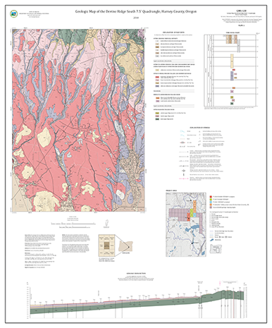
MAP PLATE (georeferenced PDF, 34 x 41 inches, 7.2 MB)
Plate 1. Geologic map of the Devine Ridge South 7.5' quadrangle, Harney County, Oregon, 1:24,000
Note: The map plate PDF is in geospatial PDF format, allowing you to turn on and off layers in the map frame and to find geographic coordinates in the PDF.