DOGAMI Geologic Map Series
[Go back] | Publications Center | DOGAMI Home
Publication Preview
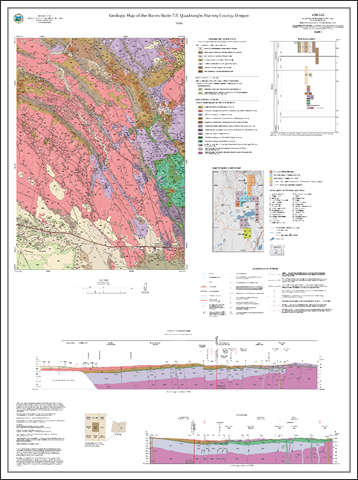
 GMS-125, Geologic Map of the Burns Butte 7.5' Quadrangle, Harney County, Oregon, by Jason D. McClaughry, Carlie J. M. Duda, and Mark L. Ferns; 163 p. report; 1 map plate (35 x 47 inches), scale 1:24,000; Esri format geodatabase; shapefiles; metadata; spreadsheets.
Publication Downloads:
- Report (163 p., 55 MB PDF)
- Map plate, with cross sections (georeferenced PDF): Plate 1, Burns Butte (7.5 MB)
- GIS metadata only bundle (22 .xml files; 86 KB .zip file)
- GIS data:
- Data spreadsheet: bedding, geochemistry, geochronology, orientation, wells (389 KB, Microsoft Excel .xlsx format)
- Age data bundle (spreadsheets, Excel files, PDFs; 1.6 KB .zip file)
- Complete publication (report, map plates, geodatabase, shapefiles, metadata, spreadsheet; 66 MB zip file)
INTRODUCTION [from the report]
The geology of the Burns Butte 7.5' quadrangle was mapped by the Oregon Department of Geology and Mineral Industries (DOGAMI) during 2019 and 2020 (Figure 1-1; Plate 1). This mapping is part of a multi-year geologic study of the Harney Basin, designated a high priority by the Oregon Geologic Mapping Advisory Committee (OGMAC). Key objectives of this project are to 1) provide an updated and spatially accurate geologic framework for the quadrangle, referred to as the map area in the following report; 2) correlate lithologic units to surrounding areas; 3) improve the understanding of the structural and lithologic controls on groundwater aquifers; and 4) describe the occurrence of geologic resources (aggregate, industrial, mineral, and energy) and geologic hazards within the map area. This study was supported in part by a grant from the STATEMAP component of the National Cooperative Geologic Mapping Program (G19AC00160). Additional funds were provided by the State of Oregon.
The core products of this study are this report, an accompanying geologic map and cross sections (Plate 1), an Esri ArcGIS™ geodatabase, and Microsoft Excel® spreadsheets tabulating point data. The geodatabase presents the new geologic mapping in a digital format consistent with the U.S. Geological Survey (USGS) National Cooperative Geologic Mapping Program (NCGMP) Geologic Map Schema (GeMS), version 2.7 (U.S. Geological Survey, 2010; U.S. Geological Survey, 2018). This geodatabase contains spatial information, including geologic polygons, contacts, structures, geochemistry, geochronology, bedding, and water well data, as well as data about each geologic unit such as age, lithology, mineralogy, and structure. Digitization at scales of 1:8,000 or better was accomplished using a combination of 1-m lidar digital elevation models (DEMs) and 1-m 2016 National Agriculture Imagery Program (NAIP) digital orthophotos. Surficial and bedrock geologic units contained in the geodatabase are depicted on the map plate at a scale of 1:24,000. Both the geodatabase and the digital geologic map are supported by this report, which describes the geology in detail.
Collectively, this work refines our understanding of geologic conditions that control the distribution, quantity, and quality of groundwater resources, the distribution of terrain susceptible to landslides, the nature of seismic hazards, and the distribution of potential aggregate sources and other mineral resources in the Burns Butte 7.5' quadrangle. New detailed geologic data presented here also provide a basis for future geologic, geohydrologic, and geohazard studies in the greater Harney Basin.
GEOGRAPHIC INFORMATION SYSTEM (GIS) DATA
Geodatabase is Esri® version 10.7 format.
Metadata is embedded in the geodatabase and in the shapefiles and is also provided as separate .xml formatted files.
| BB2020_GeMS_v10.7.gdb (geodatabase only, with embedded metadata; 7.2 MB zip file) |
| Feature dataset classes |
| Name |
Description |
Metadata
bundle (zip) |
| CartographicLines |
Vector lines that have no real-world physical existence and do not participate in map-unit topology. The feature class includes cross section lines used for cartography for the Geologic Map of the Burns Butte 7.5' Quadrangle, Harney County, Oregon. |
.xml |
| ContactsAndFaults |
This feature class represents the boundaries between map units as depicted in the MapUnitPolys feature class, and faults within map units, all held within this geodatabase. The attributes of this feature allow the authors to indicate their confidence in the location and existence of geologic contacts and faults. This geodatabase contains cartographic representations for line symbols from Sections 1 and 2 of FGDC Digital Cartographic Standard for Geologic Map Symbolization (FGDC Document Number FGDC-STD-013-2006). |
.xml |
| DataSourcePolys |
Polygons that delineate data sources for all parts of the geologic map. These sources may be a previously published map, new mapping, or mapping with a certain technique. For a map with one data source, for example all new mapping, this feature class would contain one polygon that encompasses the map area. |
.xml |
| GeochemPoints |
New and compiled geochemical analyses are included in the geodatabase, a separate Microsoft Excel® spreadsheet named BB2020_Geochemistry.xls is also provided. Descriptive rock unit names for igneous rocks are based on normalized major element analyses plotted on the total alkalis (Na2O + K2O) versus silica (SiO2) diagram (TAS).This feature class does not have any cartographic representations associated with its features. Please see the accompanying report for more detailed information on the map units and their attributes. |
.xml |
| GeochronPoints |
New and compiled K/Ar and/or Ar/Ar isotopic age analyses are included in the geodatabase, and are also provided as a Microsoft Excel® spreadsheet named BB2020_Geochronology.xls. This feature class does not have any cartographic representations associated with its features. Please see the accompanying report for more detailed information. |
.xml |
| GeologicLines |
This feature class identifies structural folds, lineaments, joints, and dikes located within the project study area. Features within this dataset are represented as vector lines. The vector line shows the approximate location and the angle down from horizontal of the plane that bisects the fold, as well as the general angle that the layers of rock dip away from that plane. This geodatabase contains cartographic representations for line symbols from Section 5 of FGDC Digital Cartographic Standard for Geologic Map Symbolization (FGDC Document Number FGDC-STD-013-2006). |
.xml |
| MapUnitPoints |
This feature class represents map unit points used in conjunction with the ContactsAndFaults feature class to generate the MapUnitPolys feature class. |
.xml |
| MapUnitPolys |
This feature class contains map unit polygons that represent bedrock and surficial geologic units drawn by the authors within the project study area. The attributes within this feature class are provided as a descriptive summary for each unit. The unit descriptions and derivation methods can be found in the accompanying report. This feature class does not have any cartographic representations associated with its features. Please see the accompanying report for more detailed information. |
.xml |
| OrientationPoints |
The points in this feature class represent the orientation measurements of structure planes (bedding attitudes, foliation attitudes, slip vectors measured at a point, etc.) within the area of study. |
.xml |
| WellPoints |
Point data are included in the geodatabase, a separate shapefile named Wells, and are also provided as a Microsoft Excel® spreadsheet named BB2020_Wells.xls. The well log database is derived from written drillers’ logs provided by Oregon Department of Water Resources (OWRD). This feature class does not have any cartographic representations associated with its features. Please see the accompanying report for more detailed information. |
.xml |
| Tables |
| DataSources |
This part of the GeMS file geodatabase contains a table called DataSources. It lists the references used to construct the Geologic Map of the Burns Butte 7.5' Quadrangle, Harney County, Oregon. The tables attributes include sources of data, descriptions, techniques, etc., that can be used to associate features and other table entries with a data source. |
.xml |
| DescriptionOfMapUnits |
This table in the GeMS file geodatabase captures the content of the Description of Map Units (DMU), or equivalent to the List of Map Units and associated pamphlet text, included in the Geologic Map of the Burns Butte 7.5' Quadrangle, Harney County, Oregon. |
.xml |
| GeoMaterialDict |
This table in the GeMS file geodatabase contains the terms and definitions for the NGMDB Geologic Materials Classification which is intended to characterize a map unit with a generalized category based on lithologic and genetic criteria; it applies to the map unit as a whole. |
.xml |
| Glossary |
This table in the NCGMP09 file geodatabase is a glossary of the terms or words found in or related to the geodatabase and the companion pamphlet for the Geologic Map of the Burns Butte 7.5' Quadrangle, Harney County, Oregon. |
.xml |
| |
SHAPEFILES (GIS shapefiles only bundle, with metadata; 263 KB, zip file) |
BB2020_Geochemistry.shp
BB2020_Geochronology.shp
BB2020_Orientation.shp
BB2020_RefMap.shp
BB2020_Wells.shp
BB2020_XSectionLine.shp |
See descriptions above. |
.xml
.xml
.xml
.xml
.xml
.xml |
MAP PLATE (georeferenced PDF)
Plate 1. Geologic Map of the Burns Butte 7.5' Quadrangle, Harney County, Oregon, scale 1:24,000
Note: The map plate PDF is in geospatial PDF format, allowing you to turn on and off layers in the map frame and to find geographic coordinates in the PDF.